Together with my friend Monica, we decided to continue hiking the MacLehose Trail. It’s a fantastic trail, with amazing scenery and landscape. But the only challenge is that the stages 1-4 are so far away from where we live… it would almost be quicker to fly to Bangkok then to take the ferry, MTR, bus and minibus to reach the starting point of stage 2. All together it took me three hours from leaving my flat at 7.50am to 10.30am when we set out foot on the trail.
Stage 2 runs from Long Ke to Pak Tam Au and is 13.5km long. The average hiking time is estimated to be 5 hours. However, last time we hiked the first stage (which was in February this year, I can’t believe how lazy we’ve been), we already started part of the second stage. That’s because we had to find an exit point and the best exit point is at the Sai Wan pavilion. Therefore, the first set of pictures of stage 2 were taken earlier this year in February – when the weather was so much nicer than yesterday!


We were unlucky with the weather yesterday. It started off cloudy but dry, but throughout our hike the weather turned more and more miserable and not only did I manage to miss my step while crossing a small river and soaked my shoes, I also placed my backpack in a pile of cow poo (which looked like a rock… but luckily a stream of fresh water was close by so I could clean my backpack) and finally we had to walk 5km through heavy showers. We were soaked to our bones. But let’s start in chronological order.
We started yesterday by meeting at the MTR Diamond Hill Station, Exit C2 (thanks for the birthday macaroons Monica, what a nice surprise!) and we took bus 92 to Sai Kung bus terminus. As we could not find minibus NR29 outside of the McDonald’s we just took a taxi for 85HKD to Sai Wan Pavilion.


We followed the path to the small village of Sai Wan, with its small houses, few cafes and shops selling drinks and beach gear, and then climbed up a small hill to reach Ham Tin with its beautiful beaches.
At this point of the hike we saw a few other fellow hikers, mostly guys, who were listening to romantic music on their radios or music players and were all in amazing shape. They were really fit, while I struggled the hills up and down – it’s clearly time to do more hikes now!


We walked along the Ham Tin beaches. As you can tell, the weather was already changing and big clouds were building up. It was not raining… yet. But the rain was soon to come. We had already wrapped our mobile phones in plastic bags and stored everything away that was not water proof.

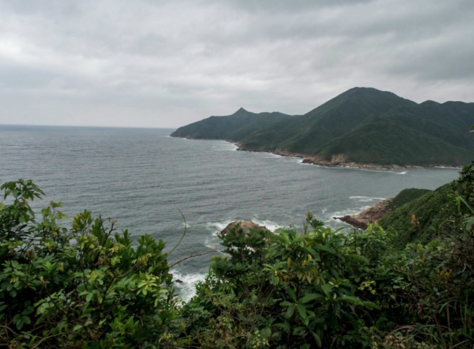
From there the trail turns inland over the coastal hills and goes through dense vegetation – which is great because it protected us from some of the rain, but unfortunately not enough. We got soaking wet from head to shoes. My shoes were wet first, as I missed a stone during a small river crossing, but after a while the rain was so strong that Monica’s shoes were wet too.
There must have been some nice beaches and shallow sea inlets – but the rain was now so strong that we could not see anything – we kept our eyes to the path and kept moving. We finished at Pak Tam Au at 2pm and took the first cab back to the MTR. We had enough for the day! Unfortunately, we’ll still have got stage 3 in front of us, for which we’ll need to travel to Sai Kung again. After that it should be easier to reach the starting points!
Anyway, here’s the map for the Tai Long Wan Hike: 

hey.. i did these stages in March this year. Stage 3 is much more strenuous than stage 2, it starts with very steep climb to the left off the road in Pak Tam Au, and the further road is somewhere boulder stones mixed with dirt, i mean it was not convenient to hike even in dry weather and i think the stones will get slippery in rain and with soaked dirt it will get muddy. I did this track in opposite direction. Disembarked in Sai Kung and by foot went uphill through the village, through terminus of GMB 3, found “Ma On Shan country trail”, reached McLehose trail going along the ridge (it was first third of section 4) and turned right, so i did not have to go extra with bus 299 to Shui Long Wo. So i did that part of stage 4, visiting Ma On Shan itself and then full stage 3. Well, it’s not for beginners, but on the other hand it’s not something impossible to do, besides you’d be rewarded by helicopter views from the top of Ma On Shan if the weather is right. If you do stage 3 only, any direction, there are nice view from outermost hills, towards Tolo harbour from Kai Kung Shan, or towards Wong Shek and Sharp peak from Ngau Yee Shek Shan, i.e. the root you already did the other day. In short, have a nice hiking, HK hills are great any time of year )
Wow – thanks so much for all the detail. I’m not sure know if I’m looking forward to stage 3 or if I will chicken out :) But it sounds like the views are worth it, so I might have to wait for a cloudy (but not rainy) day to give this stage a go.
Hi! I am flying to HK tomorrow for 2 weeks (part of my time will be spent in Taiwan). I’ll probably look through some of your other posts for ideas. I want to do a hike and had been planning to do it with my cousin, but it turns out that he won’t arrive in HK until the day I leave. I am interested in doing stage 2 of the MacLehose, and would not call myself a regular hiker even though I’d love to do more hiking. Considering that it’s July (expecting crazy humidity in HK), would you recommend that I do this part of the hike on my own?
Hi Alison, thanks for stopping by. It’s a beautiful hike, but given it is quite remote I would not recommend you go by yourself. Especially in this heat right now! Also, in a perfect world, you should never hike on your own. It’s safer if you are with hiking buddies. Maybe check out the HK Hiking group on MeetUp, you can join them even if you are only a visitor – they have several hikes planned in the next days. There might be one for you? So you won’t have to worry about being on your own and the exact route to take… have a great time! Safe travels & hiking!